Learning & methods · November 2026学习与方法 · 2026 年 11 月
Are unseen places reconstructed or imagined?看不见的地方,是重建还是想象?
Atlas organizes images and camera poses into a spatial context. More views constrain generation, but a navigable 3D world is not a fully measured reality.Atlas 把图像与相机位姿组织成空间上下文。更多视角能约束生成,但可漫游的 3D 世界不等于完整测量过的现实。
1 · A facade photograph does not determine the back1 · 一张立面照片,不决定建筑背面
给模型一张建筑正面照片,要求镜头绕到背面。背面有窗、无窗,或连着一个院子,都可能与同一张正面照片相容。模型能生成连续的环绕画面,说明它为缺失部分选出了一种解释;仅凭这张照片,无法证明这种解释就是现实。
World Labs 在 2026 年 9 月发布的 Atlas,将这种“已有证据”和“未知空间”的关系放进统一的生成系统。它接受文字、图像、相机位姿和深度,生成新视角以及几何表示。与只把图片按时间排成视频不同,输入图像带有空间位置:模型不仅知道看到过什么,还知道从哪里看到。
这篇文章依据官方发布页和其归档原文。它是一份系统技术说明,披露了架构方向、演示与部分评测;没有给出足以重建训练过程的完整技术配方。理解它最有价值的切口,是空间上下文怎样约束生成,以及这些约束还留下多少未知。
Give a model a photograph of a building's front and ask a camera to orbit behind it. Windows, a blank wall, or a courtyard at the back could all be compatible with the same front view. A continuous generated orbit shows that the model selected one explanation for missing information. That photograph alone cannot establish that the explanation is real.
World Labs introduced Atlas in September 2026 as a system combining evidence about a scene with generation beyond it. It accepts text, images, camera poses and depth, and generates novel views and geometric representations. Instead of treating images only as a temporal video sequence, it grounds them in space: the model knows both what was seen and where it was seen from.
This article uses the official announcement and its archived text. The announcement describes an architecture direction, demonstrations and selected evaluations, not a complete reproducible training recipe. The useful question is how spatial context constrains generation, and what remains unknown under those constraints.
2 · Each image in the context has a viewpoint2 · 上下文里,照片还带着一个机位
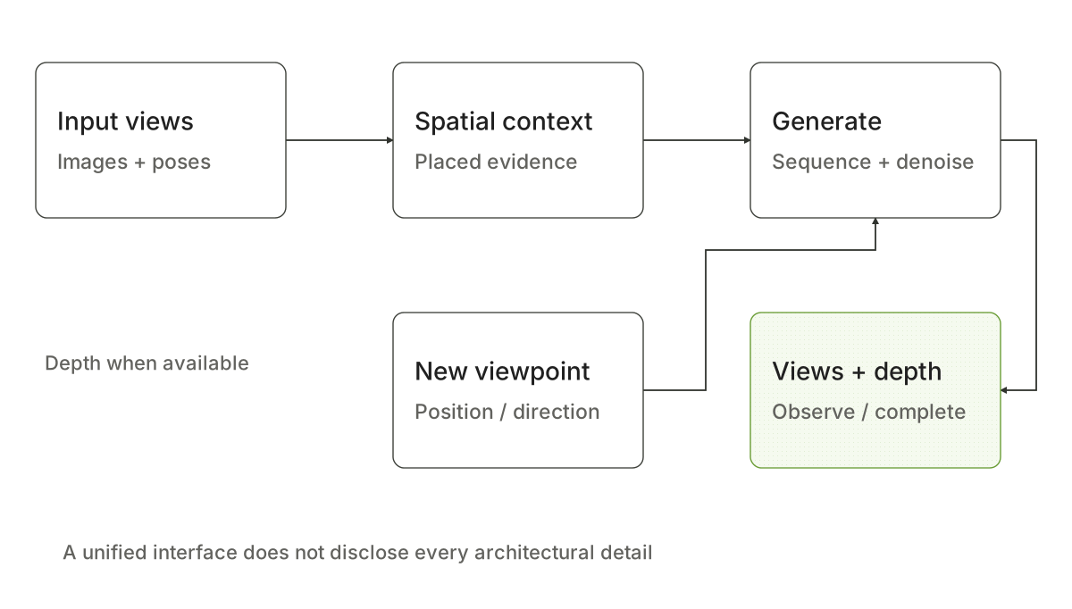
普通相册给出若干画面,却没有明确告诉模型相机之间如何移动。Atlas 把图像、深度与相机位姿作为原生数据类型,组成同一序列;每幅图像和深度图都有对应位姿。生成新视角时,查询位置与已有证据之间的空间关系也进入条件。
An ordinary image album does not explicitly say how its cameras moved relative to one another. Atlas treats images, depth and camera poses as native data types in one sequence, associating each image and depth map with a pose. A query for a novel view also supplies its spatial relationship to the available evidence.
Static diagram静态图
可用下面的教学表达记住接口,而不是把它当作官方公开的实现公式:
是输入图像, 是相机位姿, 表示在任务中可用的深度信息,并非每次输入都要求深度; 是待查询机位。花括号只用于收集这些带位姿证据,实际模型仍按多模态序列处理,不能据此推断架构对输入顺序严格不变。
这种接口还允许创作性用法:把一张书房与一张庭院图片分别放在两个位置,生成连接它们的走廊。走廊不是被发现的真实空间,而是满足端点条件的补全。对于设计,这是可控创作;对于勘测,必须避免把它当作已观测事实。
The following teaching notation captures the interface, rather than reproducing a disclosed implementation formula:
is an input image, its pose, and depth information when available for the task; depth is not required in every input. is the queried camera pose. The braces collect pose-grounded evidence for explanation. The actual model processes a multimodal sequence, so this notation does not imply strict invariance to input order.
The interface also supports a creative use: place an image of a study and one of a courtyard at two locations, then generate a connecting corridor. The corridor is a completion consistent with endpoints, not a discovered real space. That is useful control for design; it must not be mistaken for observed evidence in surveying.
3 · Autoregression orders outputs; diffusion generates them3 · 自回归决定接什么,扩散决定怎样画
官方将 Atlas 描述为多模态自回归扩散 Transformer。三个词对应不同层次:多模态规定序列中可以有什么,自回归规定新元素依赖前面的上下文,扩散规定连续输出如何由噪声逐步生成。它们可以同时成立,不需要在“像语言模型”与“像视频模型”之间二选一。
例如,已有若干带位姿图像,要查询新机位。序列先放输入证据,再加入待生成元素的条件;生成该元素时使用 rectified flow 去噪。得到新的元素后,它可以成为后续生成的上下文。这里描述的是官方披露的分工,不能据此补写未公开的 token 设计、注意力掩码或具体缓存策略。
要点在于:一个一致的空间可以从多个观察位置被查询,不必把每次请求当作全新的独立视频。已有输出也会产生新的依赖,因此模型若早先补错了空间,后续画面可能一致地延续那个错误。“各张图互相一致”和“它们都符合现实”,仍然是两种标准。
这也解释了为什么“有深度输出”不能直接推出“内部一直维护一个几何正确的 3D 引擎”。发布页确认的是能处理深度并生成显式输出;公开描述没有给出一套保证所有预测满足真实几何与动力学的硬约束。
The official description calls Atlas a multimodal autoregressive diffusion transformer. These terms concern different levels. Multimodality specifies what can appear in the sequence. Autoregression conditions each new element on earlier context. Diffusion describes how continuous outputs are progressively generated from noise. The system need not choose between being language-model-like and video-model-like.
Suppose several pose-grounded images are available and a new camera view is requested. Evidence enters the sequence, followed by conditions for the requested element; rectified-flow denoising generates that element. It can then become context for later outputs. This describes the roles disclosed publicly, without inventing tokenizer designs, attention masks or specific caching policies that were not disclosed.
The important idea is that one space can be queried from different viewpoints rather than treating every request as an independent new video. Earlier generated outputs also create dependencies. If the model initially completes the space incorrectly, later images may consistently extend that error. Agreement between views and agreement with reality remain different standards.
Depth output therefore does not establish that the system always maintains a geometrically correct internal 3D engine. The announcement confirms depth handling and explicit outputs. It does not provide hard constraints guaranteeing that all predictions obey real geometry and dynamics.
4 · From depth to an explorable asset4 · 从深度到可漫游资产,中间发生了什么?
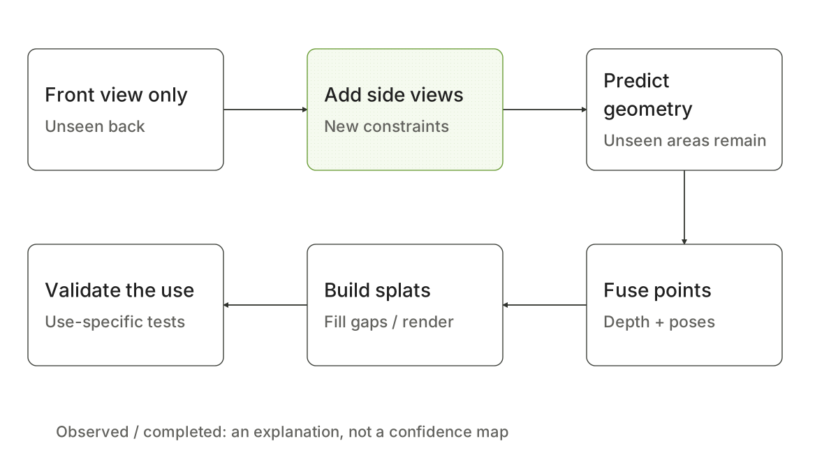
发布页描述两类输入路径:单图可联合生成新视角和几何;现实视频可逐帧预测深度,再组合为点云。随后填补空缺,形成可以在设备上渲染的 Gaussian splat 场景。点云提供空间采样点,splat 用带颜色和形状的高斯基元形成可观看的表面外观。
The announcement describes two input paths: a single image can lead to jointly generated novel views and geometry, while real video can yield depth for each frame and a combined point cloud. Filling remaining gaps produces a Gaussian splat scene that can render on a device. A point cloud supplies spatial samples; splats use Gaussian primitives with color and shape to produce a viewable appearance.
Static diagram静态图
标准相机几何可以说明为什么深度与位姿必须配合。假设采用针孔相机、 表示沿光轴的深度,则一个像素映射到世界点可写为:
是相机内参, 把相机坐标旋转到世界坐标, 是相机中心。这里是通用几何解释,不是声称 Atlas 公开了这段内部计算。若深度或位姿有误,融合出的点也会偏;能导出点云并不会自动消除输入与预测误差。
回到建筑照片:第一张只约束正面,第二张侧面照片会减少侧面的不确定性,第三张背面照片才能直接约束背面。Atlas 官方花园、小屋和主屋的逐步加图演示,呈现的正是这种“增加观测,减少补全”的过程。即使画面已经填满,也不能据此说整个空间都被测量过。
可漫游资产适合展示与视角合成;若要用来做机器人碰撞规划、尺寸测量或结构分析,还需要对应的尺度、几何与物理验证。视觉上连续的 splat 也不自动等于有语义、可碰撞、水密的网格模型。
Standard camera geometry explains why depth and pose must work together. Under a pinhole camera, with defined as optical-axis depth, a pixel maps to a world point as:
denotes camera intrinsics, rotates camera coordinates into world coordinates, and is the camera center. This is a general geometric explanation, not a claim that Atlas discloses this exact internal computation. Errors in depth or pose displace the fused points; point-cloud export does not erase input or prediction errors.
Return to the building: a front photograph constrains its front. A side photograph reduces uncertainty about that side. A rear photograph directly constrains the back. The official garden, cottage and main-house demonstration illustrates this gradual replacement of completion with observations. A filled image does not mean a fully measured space.
An explorable asset can serve presentation and novel-view synthesis. Collision planning, measurement and structural analysis require their own validation of scale, geometry and physics. A visually continuous splat is not automatically a semantic, collision-ready, watertight mesh.
5 · How should a seemingly complete world be judged?5 · 怎样评价一个“看起来完整”的世界?
Atlas 官方评测有两个不同任务。相机控制比较的是生成结果多好地遵从目标运镜;Atlas 接受原生相机轨迹,其他视频模型通过文字接收运镜指令。因此,这项结果体现整个控制接口和系统的表现,不能单独归因为更好的视觉生成主干。
稀疏视角重建则给图像和位姿,比较输入像素对应 3D 点的误差。它直接涉及几何准确性,但评估的是给定观测对应的点,不会自动验证所有补全的背面、长期动态或接触物理。两项测量都应保留各自的任务范围,不必拼成“所有世界能力都更好”的结论。
对建筑与城市场景,较实际的阅读方式是分别标清:哪些视角来自现场,哪些是新视角合成,哪些地方没有观测、依赖生成补全。本文图中的“观测约束”和“补全区域”是解释性的区分,不能当作 Atlas 已输出逐点置信度或不确定性地图的证据。
如果目标是设计一个尚不存在的空间,想象部分正是价值;如果目标是还原现实,新增视角与验证会更重要。这一区别也连接到状态与观测:一份观测只约束世界状态的一部分。若关注的是动作如何改变世界,则继续读视频世界模型的预测检验。空间补全、动态预测与行动规划可以相接,但各自需要独立的证据。
The official Atlas evaluations address two tasks. Camera-control comparison measures how well outputs follow the requested movement. Atlas receives native camera trajectories, while other video models receive camera instructions as text. The result therefore reflects the control interface and overall system, not solely the quality of a visual generation backbone.
Sparse-view reconstruction supplies images and poses and evaluates errors in 3D points corresponding to input pixels. This directly concerns geometric accuracy, but points associated with available observations do not automatically validate every completed back surface, long-term dynamics or contact physics. Each measurement should retain its task scope rather than becoming one claim of superiority across all world-model abilities.
For architectural and urban scenes, a practical interpretation separates on-site observations, synthesized novel views, and unobserved regions filled by generation. The observed-constraint and completion distinction in this article's diagrams is explanatory. It is not evidence that Atlas outputs pointwise confidence scores or uncertainty maps.
If the goal is to design a space that does not exist yet, imagination is part of its value. If the goal is to recover reality, additional viewpoints and validation matter more. This connects to state and observation: an observation constrains only part of a world state. For how actions change the world, continue with testing video-world predictions. Spatial completion, dynamic prediction and action planning can connect, but each requires its own evidence.
Continue reading继续阅读
- World Labs · Atlas (1 September 2026)
- Original study notes原始学习笔记 · atlas explained
- Original study notes原始学习笔记 · atlas source